File:Tuscan archipelago.png

Dimension de ci prevision: 800 × 550 pixeles. Altri resolutiones: 320 × 220 pixeles | 640 × 440 pixeles | 1,000 × 687 pixeles.
Original file (1,000 × 687 pixeles, dimension del file: 200 KB, tip MIME: image/png)
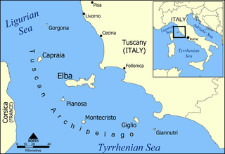
| Descrition | A map of the Tuscan archipelago, including the islands Elba, Capraia, Giglio, Montecristo, Pianosa, Gorgona, and Giannutri. Tyrrhenian Sea. |
| Date | |
| Fonte | Propri ovre |
| Autor | Created by NormanEinstein |
| Other versions |
A blank version of this map is available at: Image:Tuscan archipelago blank map.png |
I, the copyright holder of this work, hereby publish it under the following licenses:

|
Permission es concedet por copiar, distribuer e/o modificar ti document sub li conditiones del Autorisation de Documentation Líber del GNU, Version 1.2 o qualcunc version posteriori publicat per li Free Software Foundation; che nequant Section Ínvariant, nequant Textu de Covriment, e nequant Textu de Contra-Covriment. Un copie del autorisation es includet in li section nominat Autorisation de Documentation Líber del GNU. |
| Ti file is autorisat sub li autorisation Creative Commons - Atribution-Distribution in Conditiones de Egal Autorisation 3.0 Non-Adaptat. | ||
Vu posse far in qualcunc forme rasonabil, ma ne de forma que suggeste que li autorisator indossa vu o tui usu.
| ||
| This licensing tag was added to this file as part of the GFDL licensing update. |
Vu posse selecter li autorisation de tui selection.
Versiones del file
Clacca a un date/témpore por vider ti version.
| Version de | Miniatura | Dimensiones | Usator | Comentarie | |
|---|---|---|---|---|---|
| actual | 19:32, 12 julí 2006 | | 1,000 × 687 (200 KB) | NormanEinstein | Corrected typo. |
| 19:06, 19 decembre 2005 |  | 1,000 × 688 (258 KB) | NormanEinstein | Corrected typo. | |
| 15:46, 20 may 2005 |  | 800 × 550 (195 KB) | NormanEinstein | Slightly modified version with brighter colours. | |
| 10:42, 20 may 2005 |  | 1,000 × 687 (238 KB) | Airunp | From en:Image:Tuscan archipelago.png A map of the Tuscan archipelago, including the islands Elba, Capraia, Giglio, Montecristo, Pianosa, Gorgona, and Giannotri. I made this. {{PD-self}} Category:France Category:Maps |
Usu del file
Hay nequant págine que usa ti file.
Usu global del file
Li altri wikis a sequer usa ti-ci file:
- Usu in af.wikipedia.org
- Usu in als.wikipedia.org
- Usu in ar.wikipedia.org
- Usu in arz.wikipedia.org
- Usu in azb.wikipedia.org
- Usu in az.wikipedia.org
- Usu in be.wikipedia.org
- Usu in bn.wikipedia.org
- Usu in br.wikipedia.org
- Usu in bs.wikipedia.org
- Usu in ceb.wikipedia.org
- Usu in ckb.wikipedia.org
- Usu in cs.wikipedia.org
- Usu in cy.wikipedia.org
- Usu in da.wikipedia.org
- Usu in de.wikipedia.org
Vider plu del usu global de ti-ci file.