File:Tartu Raekoja plats 18 ja 20.jpg
Dimension de ci prevision: 800 × 416 pixeles. Altri resolutiones: 320 × 166 pixeles | 640 × 332 pixeles | 1,024 × 532 pixeles | 1,280 × 665 pixeles | 2,560 × 1,330 pixeles | 5,377 × 2,793 pixeles.
Original file (5,377 × 2,793 pixeles, dimension del file: 8.46 MB, tip MIME: image/jpeg)
Descrition
| Descrition |
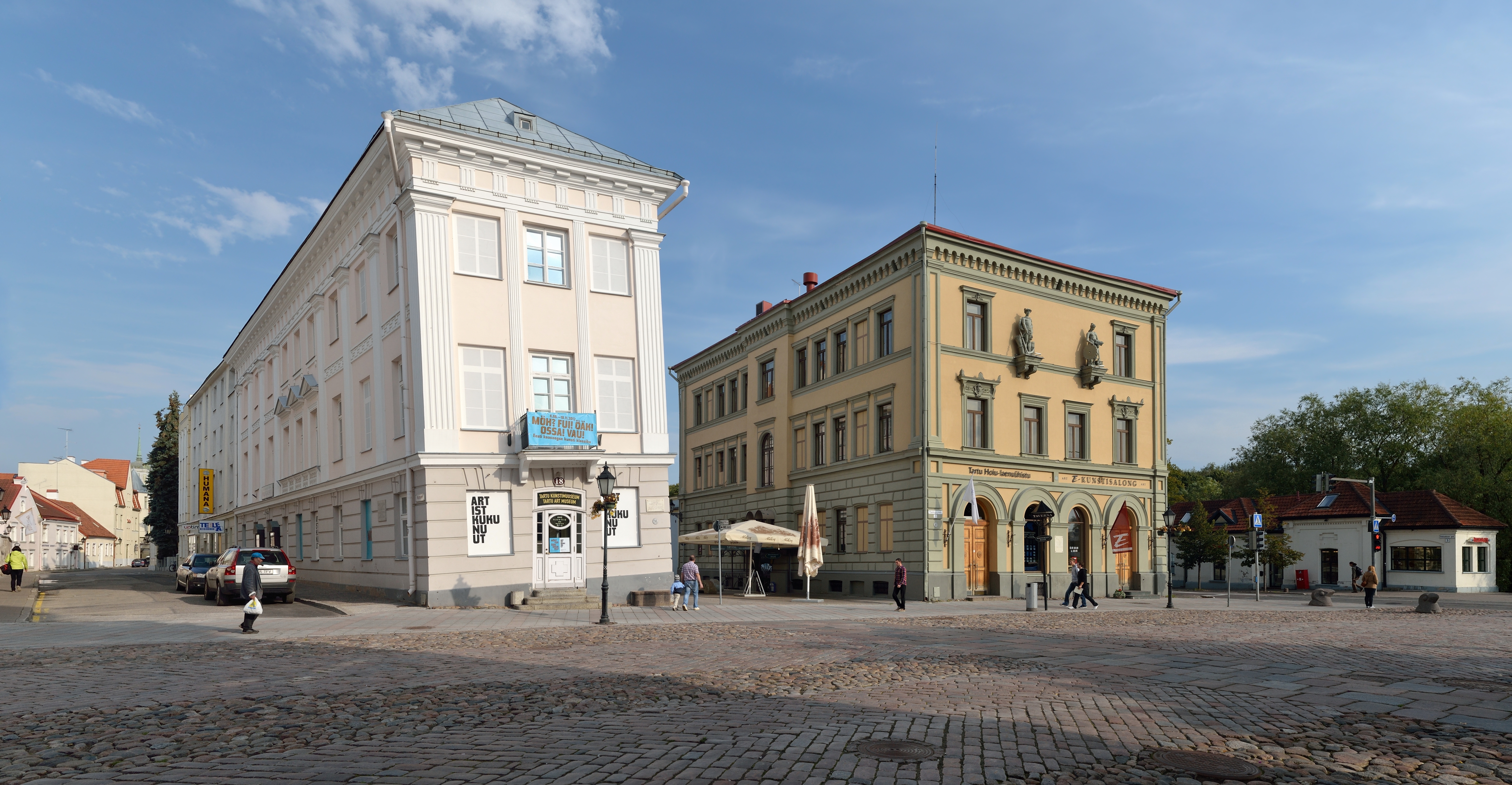
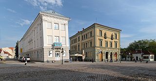
Eesti: Tartu Raekoja plats 18 ja 20 hooned. Nr 18 - elamu, nn Viltune maja, ehitatud 1793. Nr 20 - pangahoone, ehitatud 1876-1878.
English: Buildings nr 18 and 20 on Tartu Raekoja plats. Nr 18 is so called the Leaning House of Tartu, built in 1793. One side of the house is foundation supported by the old city wall and the other side by wooden poles. This is the reason why the house is leaning sideways. Nr 20 is bank building, built in 1876-1878
|
||||
| Date | |||||
| Fonte | Propri ovre | ||||
| Autor | Ivar Leidus |
| Camera location | | View this and other nearby images on: OpenStreetMap |
|---|
This image was created with Hugin.
Autorisation
I, the copyright holder of this work, hereby publish it under the following license:
This file is licensed under the Creative Commons Attribution-ShareAlike 3.0 Estonia license.
- Vu es líber:
- distribuer – a copiar, distribuer e transmisser li labor
- remixter – adaptar li ovre
- Sub li conditiones quam seque:
- atribution – Vu deve dar li credite convenent, provider un catenun por li autorisation, e indicar si changes esset fat.
Vu posse far in qualcunc forme rasonabil, ma ne de forma que suggeste que li autorisator indossa vu o tui usu.
- distribuer in conditiones de egal autorisation – Si vu remixter, transformar, o constructer sur li materiale, vu deve distribuer tui contributiones sub li autorisation identic o campatabil quam li original.

This image has been assessed using the Quality image guidelines and is considered a Quality image.
|

|
This image was uploaded as part of Wiki Loves Monuments 2012.
|
Versiones del file
Clacca a un date/témpore por vider ti version.
| Version de | Miniatura | Dimensiones | Usator | Comentarie | |
|---|---|---|---|---|---|
| actual | 05:36, 17 august 2014 | | 5,377 × 2,793 (8.46 MB) | Iifar | left crop improved |
| 18:22, 29 septembre 2012 |  | 5,777 × 2,793 (8.86 MB) | Iifar | fixed 2 stitching errors | |
| 16:22, 17 septembre 2012 |  | 5,777 × 2,793 (14.62 MB) | Iifar | User created page with UploadWizard |
Usu del file
Li sequent págine usa ti file:
Usu global del file
Li altri wikis a sequer usa ti-ci file:
- Usu in af.wikipedia.org
- Usu in az.wikipedia.org
- Usu in ba.wikipedia.org
- Usu in be-tarask.wikipedia.org
- Usu in be.wikipedia.org
- Usu in bg.wikipedia.org
- Usu in br.wikipedia.org
- Usu in ca.wikipedia.org
- Usu in cs.wikipedia.org
- Usu in cv.wikipedia.org
- Usu in da.wikipedia.org
- Usu in de.wikipedia.org
- Usu in el.wikipedia.org
- Usu in et.wikipedia.org
- Usu in fa.wikipedia.org
- Usu in fi.wikipedia.org
- Usu in fr.wikipedia.org
- Usu in gl.wikipedia.org
- Usu in hr.wikipedia.org
- Usu in hu.wikipedia.org
- Usu in id.wikipedia.org
- Usu in io.wikipedia.org
- Usu in it.wikipedia.org
- Usu in lmo.wikipedia.org
- Usu in lt.wikipedia.org
- Usu in lv.wikipedia.org
- Usu in mhr.wikipedia.org
- Usu in mrj.wikipedia.org
- Usu in ms.wikipedia.org
- Usu in nl.wikipedia.org
- Usu in nn.wikipedia.org
- Usu in os.wikipedia.org
- Usu in qu.wikipedia.org
- Usu in ro.wikipedia.org
- Usu in ru.wikipedia.org
- Usu in sco.wikipedia.org
- Usu in simple.wikipedia.org
- Usu in sk.wikipedia.org
- Usu in sv.wikipedia.org
- Usu in sw.wikipedia.org
- Usu in th.wikipedia.org
- Usu in tr.wikipedia.org
- Usu in udm.wikipedia.org
- Usu in vo.wikipedia.org
- Usu in war.wikipedia.org