File:South America-fr.svg

Size of this PNG preview of this SVG file: 528 × 600 pixeles. Altri resolutiones: 211 × 240 pixeles | 423 × 480 pixeles | 676 × 768 pixeles | 901 × 1,024 pixeles | 1,803 × 2,048 pixeles | 530 × 602 pixeles.
Original file ((file SVG, nominalmen 530 × 602 pixeles, mesura de file: 166 KB))
Descrition
| Descrition |
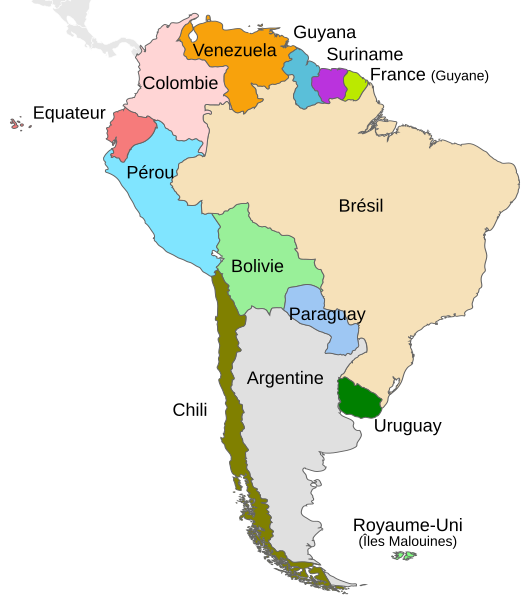
English: Political map of South America. Français : Carte politique de l'Amérique du Sud. |
||
| Date | |||
| Fonte |
This file was derived from: South America-en.svg: |
||
| Autor | DavoO Themightyquill Sémhur | ||
| SVG genesis |
|
| Object location | | View this and other nearby images on: OpenStreetMap |
|---|
Autorisation
I, the copyright holder of this work, hereby publish it under the following license:
Ti file is autorisat sub li autorisation Creative Commons - Atribution-Distribution in Conditiones de Egal Autorisation 3.0 Non-Adaptat.
- Vu es líber:
- distribuer – a copiar, distribuer e transmisser li labor
- remixter – adaptar li ovre
- Sub li conditiones quam seque:
- atribution – Vu deve dar li credite convenent, provider un catenun por li autorisation, e indicar si changes esset fat.
Vu posse far in qualcunc forme rasonabil, ma ne de forma que suggeste que li autorisator indossa vu o tui usu.
- distribuer in conditiones de egal autorisation – Si vu remixter, transformar, o constructer sur li materiale, vu deve distribuer tui contributiones sub li autorisation identic o campatabil quam li original.
Original upload log
This image is a derivative work of the following images:
- South America-en.svg licensed with Cc-by-sa-3.0
- 2010-12-23T14:03:31Z Kmusser 530x602 (186901 Bytes) delete square
- 2010-12-22T11:02:38Z Themightyquill 530x602 (187024 Bytes) unexplained black square?
- 2010-12-22T11:00:03Z Themightyquill 530x602 (187024 Bytes) Falklands, central america connection
- 2010-12-22T10:28:23Z Themightyquill 530x602 (168629 Bytes) move "argentina"
- 2010-12-22T10:27:05Z Themightyquill 530x602 (168627 Bytes) fix spelling
- 2010-12-22T10:24:02Z Themightyquill 530x602 (168233 Bytes) {{Information |Description={{en|Map of countries in South America}} |Source=*[[:File:Map-Latin_America.svg|]] |Date=2010-12-22 10:23 (UTC) |Author=*[[:File:Map-Latin_America.svg|]]: *[[:File:Map-Latin_America2.png|Map-Latin_A
Uploaded with derivativeFX
Versiones del file
Clacca a un date/témpore por vider ti version.
| Version de | Miniatura | Dimensiones | Usator | Comentarie | |
|---|---|---|---|---|---|
| actual | 19:05, 21 may 2014 | | 530 × 602 (166 KB) | Sémhur | Valid SVG |
| 20:44, 2 junio 2012 |  | 530 × 602 (167 KB) | Sémhur | == {{int:filedesc}} == {{Information |Description={{Multilingual description |en= Political map of en:South America. |fr= Carte politique de l'fr:Amérique du Sud. }} |Source={{Derived from|South_America-en.svg|display=50}} |Date=2012-06-02... |
Usu del file
Li sequent págine usa ti file:
Usu global del file
Li altri wikis a sequer usa ti-ci file:
- Usu in fr.wikipedia.org
- Usu in ht.wikipedia.org
- Usu in mg.wikipedia.org
- Usu in pcd.wikipedia.org