File:Seas of the Philippines.svg

Original file ((file SVG, nominalmen 2,106 × 3,971 pixeles, mesura de file: 517 KB))
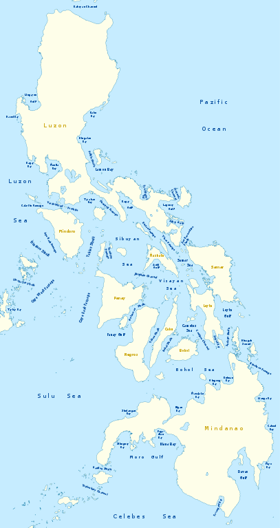
Descrition
| Descrition |
Deutsch: Karte der Seegewässer der Philippinen
English: Map of seas of the Philippines |
|
| Date | ||
| Fonte | Propri ovre, using United States National Imagery and Mapping Agency data | |
| Autor | NordNordWest | |
| Permission: (Reusant ti-ci file) |
This file is licensed under the Creative Commons Attribution-Share Alike 3.0 Germany license.
Vu posse far in qualcunc forme rasonabil, ma ne de forma que suggeste que li autorisator indossa vu o tui usu.
 Ti file is autorisat sub li autorisation Creative Commons - Atribution-Distribution in Conditiones de Egal Autorisation 3.0 Non-Adaptat.
Vu posse far in qualcunc forme rasonabil, ma ne de forma que suggeste que li autorisator indossa vu o tui usu.
|
|
| Other versions |
|


|
This map has been made or improved in the German Kartenwerkstatt (Map Lab). You can propose maps to improve as well.
|
Versiones del file
Clacca a un date/témpore por vider ti version.
| Version de | Miniatura | Dimensiones | Usator | Comentarie | |
|---|---|---|---|---|---|
| actual | 21:25, 14 februar 2011 | | 2,106 × 3,971 (517 KB) | NordNordWest | == {{int:filedesc}} == {{Information |Description= {{de|Karte der Seegewässer der Philippinen}} {{en|Map of seas of the Philippines}} |Source={{Own}}, using United States National Imagery and Mapping Agency data |Date=2012-02-14 |Author={{U|NordNordWest |
Usu del file
Hay nequant págine que usa ti file.
Usu global del file
Li altri wikis a sequer usa ti-ci file:
- Usu in de.wikipedia.org
- Usu in en.wikipedia.org
- South China Sea
- Luzon Strait
- Leyte Gulf
- Philippine Sea
- Canigao Channel
- Cebu Strait
- Sulu Sea
- Moro Gulf
- Davao Gulf
- Panay Gulf
- Bohol Sea
- Lingayen Gulf
- Surigao Strait
- Celebes Sea
- Sibuyan Sea
- Visayan Sea
- San Juanico Strait
- San Bernardino Strait
- Balintang Channel
- Camotes Sea
- Samar Sea
- Ragay Gulf
- Lagonoy Gulf
- Sorsogon Bay
- Albay Gulf
- Tablas Strait
- Mindoro Strait
- Balabac Strait
- Verde Island Passage
- Sibutu Passage
- Jintotolo Channel
- Tañon Strait
- Dinagat Sound
- Template:List of Philippine seas
- Iloilo Strait
- Guimaras Strait
- Basilan Strait
- Maqueda Channel
- Burias Pass
- Ticao Pass
- Portal:Oceans
- Usu in ilo.wikipedia.org
Vider plu del usu global de ti-ci file.