File:Mecklenburg-Vorpommern Map Districts Border Mecklenburg Western Pomerania - Landkreise Grenzen Karte MV MeckPomm.svg

Size of this PNG preview of this SVG file: 800 × 549 pixeles. Altri resolutiones: 320 × 220 pixeles | 640 × 439 pixeles | 1,024 × 703 pixeles | 1,280 × 879 pixeles | 2,560 × 1,757 pixeles | 1,129 × 775 pixeles.
Original file ((file SVG, nominalmen 1,129 × 775 pixeles, mesura de file: 759 KB))
Descrition
| Descrition |
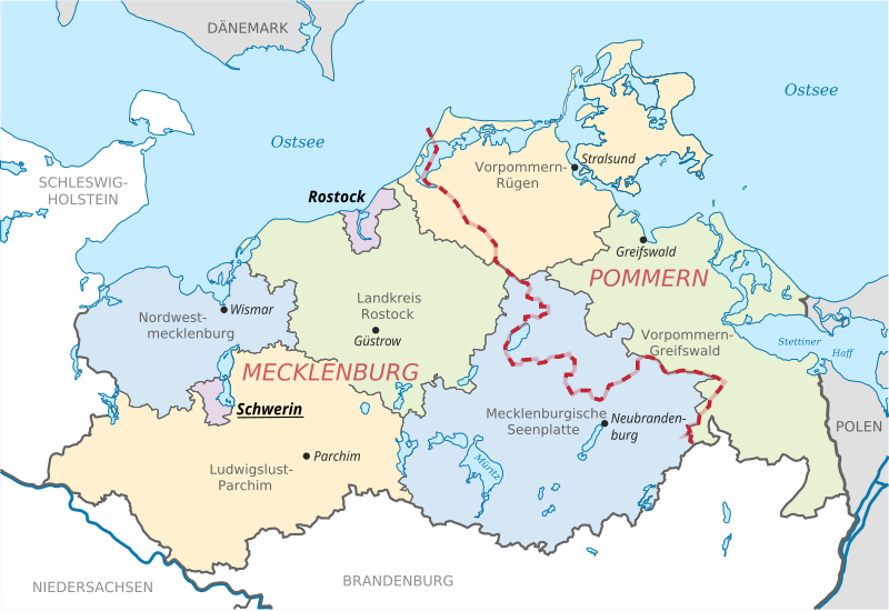
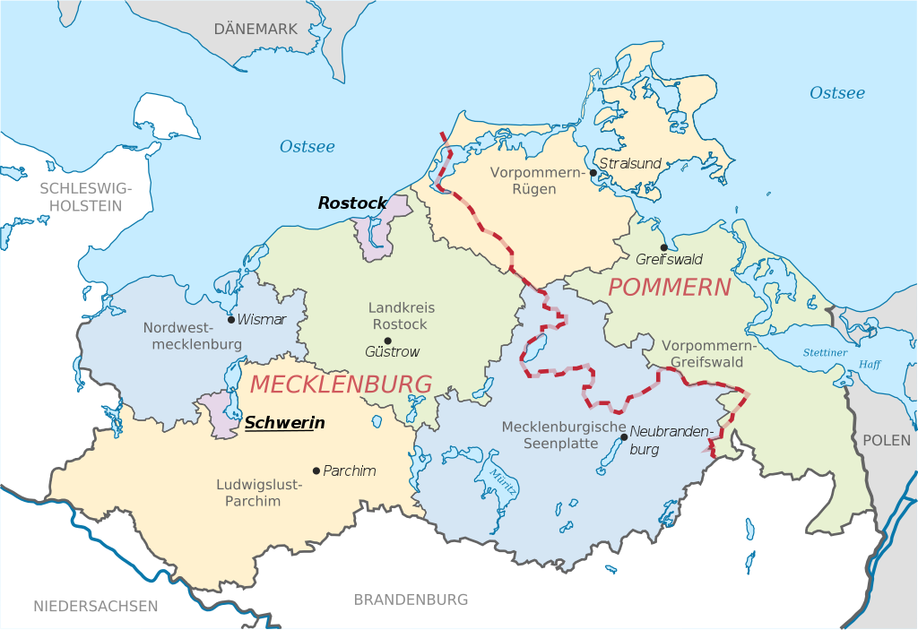
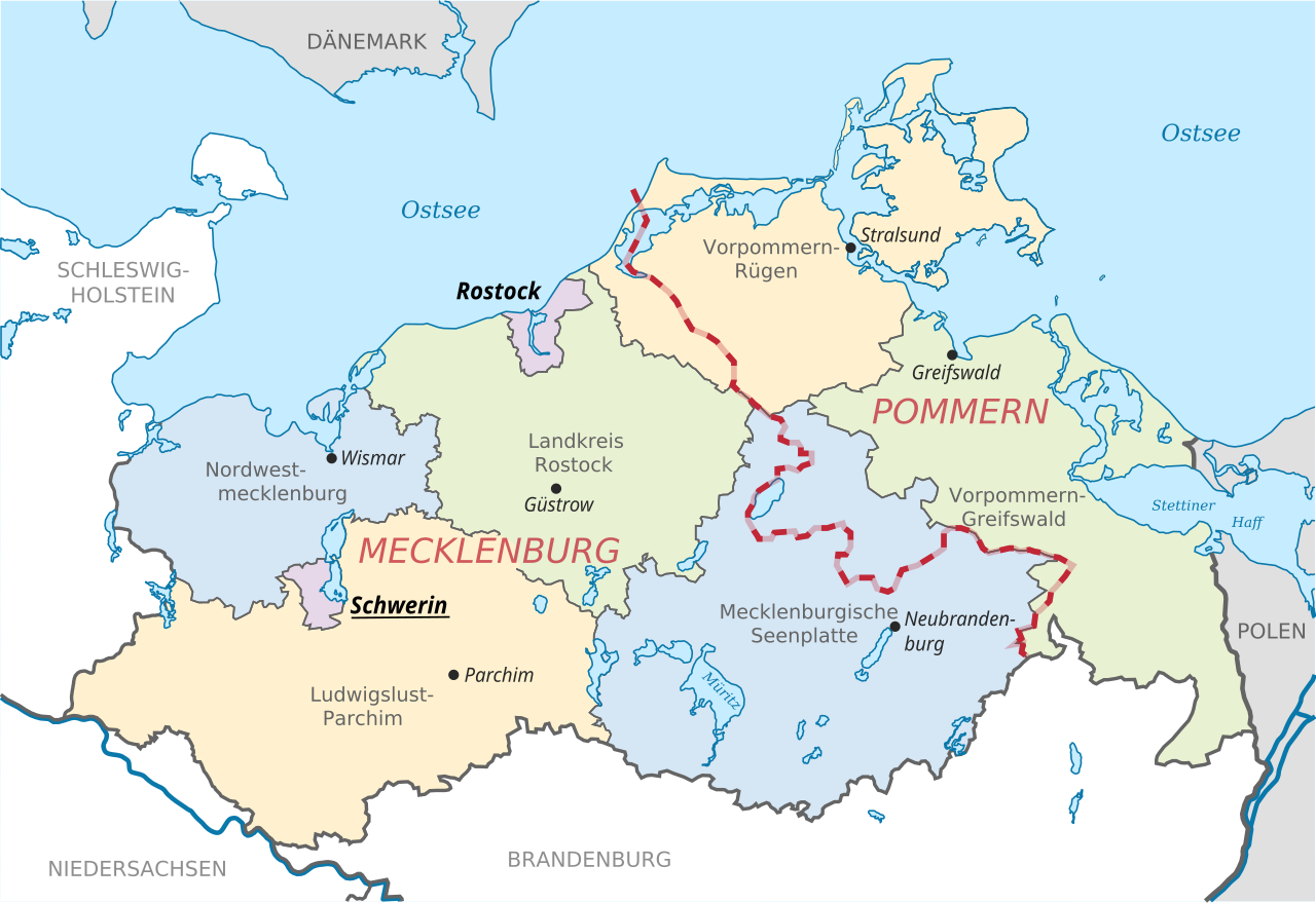
English: Locator map of counties and their seats in Mecklenburg-Vorpommern, Germany after county reorganization 2011. The red-white line indicates the former border between the state of Mecklenburg and the Prussian province of Pommerania.
Deutsch: Karte mit Lage der Landkreise und Kreisstädte in Mecklenburg-Vorpommern, Deutschland nach der Kreisgebietsreform 2011. Eingezeichnet ist auch die Grenze zwischen dem früheren Staat Mecklenburg und der preußischen Provinz Pommern. |
| Date | |
| Fonte | File:Mecklenburg-Vorpommern districts 2011 colored labeled Meck-Pomm-border.svg |
| Autor | TUBS |
| Other versions |
|


Autorisation
| This work has been released into the public domain by its author, TUBS. This applies worldwide. In some countries this may not be legally possible; if so: |
Versiones del file
Clacca a un date/témpore por vider ti version.
| Version de | Miniatura | Dimensiones | Usator | Comentarie | |
|---|---|---|---|---|---|
| actual | 11:51, 16 junio 2014 | | 1,129 × 775 (759 KB) | Horst-schlaemma | {{Information |Description ={{en|1=Locator map of counties and their seats in Mecklenburg-Vorpommern, Germany after county reorganization 2011. The red-white line indicates the former borders of the his... |
Usu del file
Li sequent págine usa ti file:
Usu global del file
Li altri wikis a sequer usa ti-ci file:
- Usu in af.wikipedia.org
- Usu in als.wikipedia.org
- Usu in an.wikipedia.org
- Usu in ast.wikipedia.org
- Usu in ay.wikipedia.org
- Usu in az.wikipedia.org
- Usu in ba.wikipedia.org
- Usu in be-tarask.wikipedia.org
- Usu in bg.wikipedia.org
- Usu in br.wikipedia.org
- Usu in ca.wikipedia.org
- Usu in csb.wikipedia.org
- Usu in cs.wikipedia.org
- Usu in cy.wikipedia.org
- Usu in de.wikipedia.org
- Usu in de.wikivoyage.org
- Usu in dsb.wikipedia.org
- Usu in en.wikipedia.org
- Usu in eo.wikipedia.org
- Usu in es.wikipedia.org
- Usu in et.wikipedia.org
- Usu in eu.wikipedia.org
- Usu in fi.wikipedia.org
- Usu in frr.wikipedia.org
- Usu in fr.wikipedia.org
- Usu in fy.wikipedia.org
- Usu in ga.wikipedia.org
- Usu in gd.wikipedia.org
- Usu in gl.wikipedia.org
- Usu in gn.wikipedia.org
- Usu in gv.wikipedia.org
- Usu in he.wikipedia.org
- Usu in hr.wikipedia.org
- Usu in hsb.wikipedia.org
- Usu in hu.wikipedia.org
- Usu in hu.wiktionary.org
- Usu in ia.wikipedia.org
- Usu in id.wikipedia.org
- Usu in ilo.wikipedia.org
Vider plu del usu global de ti-ci file.