File:Europe.jpg

Dimension de ci prevision: 680 × 600 pixeles. Altri resolutiones: 272 × 240 pixeles | 544 × 480 pixeles | 871 × 768 pixeles | 1,219 × 1,075 pixeles.
Original file (1,219 × 1,075 pixeles, dimension del file: 638 KB, tip MIME: image/jpeg)
Descrition
| Descrition |
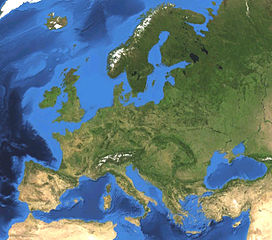
English: Satellite picture of Europe. Land terrain and bathymetry (ocean-floor topography). |
| Date | |
| Fonte | Own work by uploader, made with NASA World Wind. |
| Autor | Koyos |
| Other versions |
|


Autorisation
| I, the copyright holder of this work, release this work into the public domain. This applies worldwide. In some countries this may not be legally possible; if so: I grant anyone the right to use this work for any purpose, without any conditions, unless such conditions are required by law. |
Versiones del file
Clacca a un date/témpore por vider ti version.
| Version de | Miniatura | Dimensiones | Usator | Comentarie | |
|---|---|---|---|---|---|
| actual | 15:47, 7 februar 2009 | | 1,219 × 1,075 (638 KB) | Koyos | {{Information |Description={{en|1=Satellite picture of Europe. Terrain and ocean topography.}} |Source=Own work by uploader, made with NASA World Wind. |Author=Koyos |Date= |Permission= |other_versions= }} <!--{{ImageUpload|full}}--> [[Cat |
Usu del file
Li sequent págine usa ti file:
Usu global del file
Li altri wikis a sequer usa ti-ci file:
- Usu in be.wikipedia.org
- Удзельнік:Никита Курепин
- Удзельнік:LKS
- Удзельнік:Sir Ksandr
- Удзельнік:Чаховіч Уладзіслаў
- Удзельнік:J-ka Zadzvinski
- Удзельнік:Zemant
- Удзельнік:Mazta
- Удзельнік:Бычкоў Мікіта
- Удзельнік:Dostojewskij
- Удзельнік:Kossa b
- Удзельнік:Илья Драконов
- Удзельнік:Aliaksandr y
- Удзельнік:Петр дракона 78
- Удзельнік:Ілля Банцэвіч
- Удзельнік:BY Alex Sander
- Удзельнік:Belarusian volunteer
- Usu in ceb.wikipedia.org
- Usu in cs.wikipedia.org
- Usu in de.wikipedia.org
- Usu in en.wikipedia.org
- Usu in es.wikipedia.org
- Usu in fi.wikipedia.org
- Usu in gn.wikipedia.org
- Usu in id.wikipedia.org
- Usu in id.wiktionary.org
- Usu in incubator.wikimedia.org
- Usu in it.wikibooks.org
- Usu in kk.wikipedia.org
- Usu in pl.wikibooks.org
- Usu in pt.wikipedia.org
- Usu in sv.wikipedia.org
Vider plu del usu global de ti-ci file.