File:DomTorenUtrechtNederland.jpg

Dimension de ci prevision: 320 × 599 pixeles. Altri resolutiones: 256 × 480 pixeles | 410 × 768 pixeles | 547 × 1,024 pixeles | 1,763 × 3,300 pixeles.
Original file (1,763 × 3,300 pixeles, dimension del file: 3.64 MB, tip MIME: image/jpeg)
This image has been assessed using the Quality image guidelines and is considered a Quality image.
|
Descrition
|
This is an image of rijksmonument number 36075 Information from structured data: |
| Descrition |
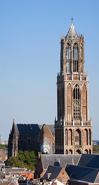
English: The Dom Tower in Utrecht, the Netherlands is one of the best known landmarks of this country. This gothic tower is the highest church tower (112,5 metres/368 feet) in the Netherlands and was built between 1321 and 1382 as part of the Cathedral of St. Martin. The resolution of the original photograph is 7768*4150.
Nederlands: De Domtoren in Utrecht, Nederland is één van de bekendste gebouwen van het land. Deze gotische toren is de hoogste kerktoren (112,5 meter) van Nederland en is gebouw tussen 1321 en 1382 als onderdeel van de Kathedraal van de Heilige Maarten. De resolutie van de oorspronkelijke foto is 7768*4150.
Français : La Cathédrale Saint-Martin d'Utrecht aux Pays-Bas. |
| Date | |
| Fonte | Propri ovre |
| Autor | Massimo Catarinella |
| Permission: (Reusant ti-ci file) |
See license, attribution required - contact me to discuss less restrictive commercial licensing terms by email Special:EmailUser/Massimo Catarinella or leave a message on my talk page |
| Other versions |
|

| Object location | | View this and other nearby images on: OpenStreetMap |
|---|
| Camera location | | View this and other nearby images on: OpenStreetMap |
|---|
Autorisation
I, the copyright holder of this work, hereby publish it under the following license:
This file is licensed under the Creative Commons Attribution 3.0 Unported license.
- Vu es líber:
- distribuer – a copiar, distribuer e transmisser li labor
- remixter – adaptar li ovre
- Sub li conditiones quam seque:
- atribution – Vu deve dar li credite convenent, provider un catenun por li autorisation, e indicar si changes esset fat.
Vu posse far in qualcunc forme rasonabil, ma ne de forma que suggeste que li autorisator indossa vu o tui usu.
Versiones del file
Clacca a un date/témpore por vider ti version.
| Version de | Miniatura | Dimensiones | Usator | Comentarie | |
|---|---|---|---|---|---|
| actual | 20:03, 31 august 2009 | | 1,763 × 3,300 (3.64 MB) | Massimo Catarinella | Slightly bigger resolution |
| 17:28, 31 august 2009 |  | 1,603 × 3,000 (3.03 MB) | Massimo Catarinella | {{Information |Description={{en|1=The Dom Tower in Utrecht, the Netherlands is one of the most well known landmarks of this country. This gothic tower is the highest church tower (112,5 metres/368 feet) in the Netherlands and was built between 1321 and 13 |
Usu del file
Li sequent págine usa ti file:
Usu global del file
Li altri wikis a sequer usa ti-ci file:
- Usu in ang.wikipedia.org
- Usu in ar.wikipedia.org
- Usu in ast.wikipedia.org
- Usu in bn.wikipedia.org
- Usu in ca.wikipedia.org
- Usu in cs.wikipedia.org
- Usu in de.wikipedia.org
- Niederlande
- Utrecht
- Liste der höchsten Sakralgebäude
- Erzbistum Utrecht (römisch-katholisch)
- Liste der Kathedralen und Basiliken in den BeNeLux-Ländern
- Utrechter Dom
- Top 100 der niederländischen Kulturdenkmäler
- Liste der Backsteinbauwerke der Gotik in den Niederlanden
- Benutzer:Ulamm/Provinz Utrecht
- Benutzer:Ulamm/Reise an der Backsteingrenze
- Benutzer:Ulamm/Backsteinbauwerke der Gotik in den Niederlanden
- Benutzer:Afus199620/Liste der höchsten Gebäude in den Niederlanden
- Usu in de.wikivoyage.org
- Usu in de.wiktionary.org
- Usu in en.wikipedia.org
- Church (building)
- Dom Tower of Utrecht
- St. Martin's Cathedral, Utrecht
- List of tallest church buildings
- Religion in the Netherlands
- User:Massimo Catarinella
- List of Rijksmonuments
- Wikipedia:Featured picture candidates/September-2009
- Wikipedia:Featured picture candidates/Domtoren, Utrecht
- Brabantine Gothic
- List of tallest buildings in the Netherlands
- User:Ulamm/List of Gothic brick buldings in the Netherlands
- List of Gothic brick buildings in the Netherlands
- Usu in en.wikivoyage.org
- Usu in eo.wikipedia.org
- Usu in es.wikipedia.org
- Usu in eu.wikipedia.org
- Usu in fi.wikipedia.org
- Usu in fr.wikipedia.org
- Usu in fy.wikipedia.org
Vider plu del usu global de ti-ci file.