File:Detailed Afroasiatic map.svg

Size of this PNG preview of this SVG file: 800 × 503 pixeles. Altri resolutiones: 320 × 201 pixeles | 640 × 402 pixeles | 1,024 × 644 pixeles | 1,280 × 805 pixeles | 2,560 × 1,609 pixeles | 1,750 × 1,100 pixeles.
Original file ((file SVG, nominalmen 1,750 × 1,100 pixeles, mesura de file: 471 KB))
Descrition
| Descrition |
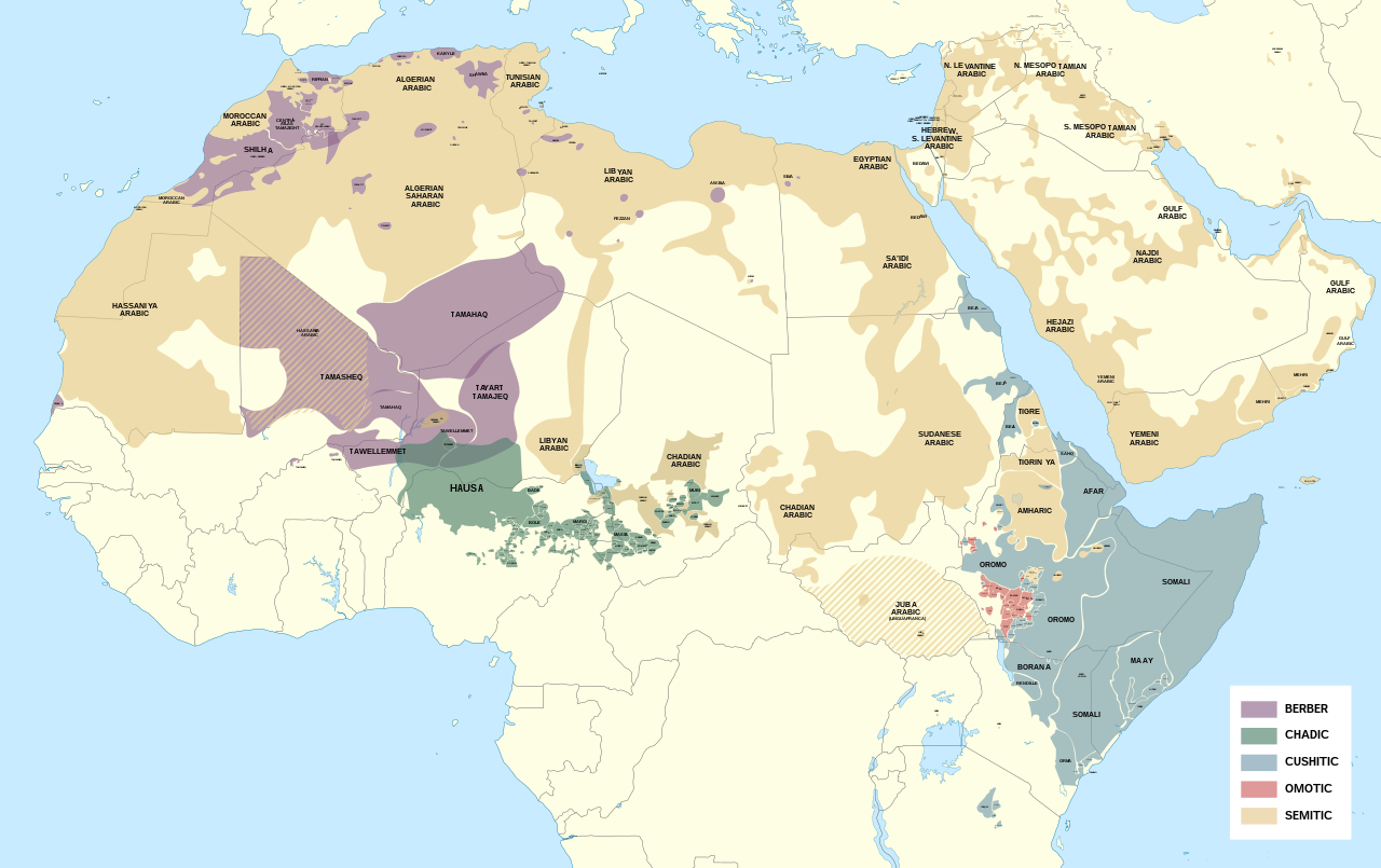
English: Detailed map of Afroasiatic languages in Africa and the Middle East.
This file was derived from: Africa map blank.svg Sources (Wikipedia): External sources:
|
| Date | |
| Fonte | Propri ovre |
| Autor | Noahedits |
![[1]](https://i.pinimg.com/originals/62/b9/94/62b994c3798bc258992de42c46e186fd.png)
![[2]](http://languages.y-bai.com/img/language_map/irq.png)
![[3]](https://i.pinimg.com/564x/8f/52/24/8f522431ee622097dc2550d9ff80480c.jpg)
![[4]](https://i.pinimg.com/originals/d7/88/71/d7887182da05cf42771989eb93960e99.png)
![[5]](https://www.ethnologue.com/sites/default/files/styles/original/public/maps/20/KE_rgb.png?itok=yGwj_XnA)
![[7]](https://www.ethnologue.com/17/sites/default/files/styles/original/public/maps/17/NG_01_rgb/index.png?itok=n1EYvDsI)
![[8]](https://www.ethnologue.com/18/sites/default/files/styles/original/public/maps/18/NG_07_rgb.png?itok=a23BiwQy)
![[9]](https://www.researchgate.net/profile/Adeiza_Isiaka/publication/317208410/figure/fig1/AS:536272059416576@1504868630079/An-index-map-for-some-Nigerian-languages-Ebira-302-is-mainly-spoken-around.png)
![[10]](https://www.researchgate.net/profile/Scott_Maceachern/publication/236160990/figure/fig2/AS:299342981287937@1448380336585/Languages-of-northern-Cameroon-Map-is-the-property-of-SIL-International-and-was-accessed.png)
![[11]](https://asmarttranslatorsreunion.files.wordpress.com/2015/11/om_rgb.png?w=584&h=889)
![[12]](https://1.bp.blogspot.com/-BeNgqhpZtGo/U3LO9MGkfOI/AAAAAAAAIqw/C4np8aWpWdQ/s1600/YE_rgb.png)
![[14]](https://i.pinimg.com/originals/89/42/66/894266f083206db69405d21bc93811a5.png)
![[16]](https://static.cambridge.org/binary/version/id/urn:cambridge.org:id:binary:20190522054803538-0373:9781108283991:41798map10_1.png?pub-status=live)
Autorisation
I, the copyright holder of this work, hereby publish it under the following license:
This file is licensed under the Creative Commons Attribution-Share Alike 4.0 International license.
- Vu es líber:
- distribuer – a copiar, distribuer e transmisser li labor
- remixter – adaptar li ovre
- Sub li conditiones quam seque:
- atribution – Vu deve dar li credite convenent, provider un catenun por li autorisation, e indicar si changes esset fat.
Vu posse far in qualcunc forme rasonabil, ma ne de forma que suggeste que li autorisator indossa vu o tui usu.
- distribuer in conditiones de egal autorisation – Si vu remixter, transformar, o constructer sur li materiale, vu deve distribuer tui contributiones sub li autorisation identic o campatabil quam li original.
Versiones del file
Clacca a un date/témpore por vider ti version.
| Version de | Miniatura | Dimensiones | Usator | Comentarie | |
|---|---|---|---|---|---|
| actual | 17:35, 13 may 2022 | | 1,750 × 1,100 (471 KB) | Noahedits | Removing Somaliland (not recognized by the international community) |
| 00:54, 19 octobre 2021 |  | 1,750 × 1,100 (549 KB) | Gebagebo | Added Somaliland | |
| 19:19, 16 may 2020 |  | 1,750 × 1,100 (471 KB) | Noahedits | Fixed error in Lake Victoria, cleaned up stray lines | |
| 17:33, 23 april 2020 |  | 512 × 322 (484 KB) | Noahedits | Adjusted location of Borana and Burji | |
| 21:04, 1 april 2020 |  | 512 × 322 (447 KB) | Noahedits | Detail in central Arabian peninsula | |
| 22:02, 7 februar 2020 |  | 512 × 325 (491 KB) | Noahedits | Cleaned up northern Iraq/Syira, fixed misidentification of Beja | |
| 06:06, 7 februar 2020 |  | 512 × 325 (480 KB) | Noahedits | Title, legend, slight clean up | |
| 05:41, 7 februar 2020 |  | 512 × 325 (479 KB) | Noahedits | User created page with UploadWizard |
Usu del file
Li sequent págine usa ti file:
Usu global del file
Li altri wikis a sequer usa ti-ci file:
- Usu in ar.wikipedia.org
- Usu in el.wikipedia.org
- Usu in en.wikipedia.org
- Usu in es.wikipedia.org
- Usu in fa.wikipedia.org
- Usu in fy.wikipedia.org
- Usu in gl.wikipedia.org
- Usu in he.wikipedia.org
- Usu in it.wikipedia.org
- Usu in ja.wikipedia.org
- Usu in lij.wikipedia.org
- Usu in mzn.wikipedia.org
- Usu in ne.wikipedia.org
- Usu in oc.wikipedia.org
- Usu in sat.wikipedia.org
- Usu in simple.wikipedia.org
- Usu in si.wikipedia.org
- Usu in sr.wikipedia.org
- Usu in sv.wikipedia.org
- Usu in tr.wikipedia.org