File:Casiquiarerivermap.png

Dimension de ci prevision: 600 × 600 pixeles. Altri resolutiones: 240 × 240 pixeles | 480 × 480 pixeles | 768 × 768 pixeles | 1,024 × 1,024 pixeles | 1,500 × 1,500 pixeles.
Original file (1,500 × 1,500 pixeles, dimension del file: 974 KB, tip MIME: image/png)
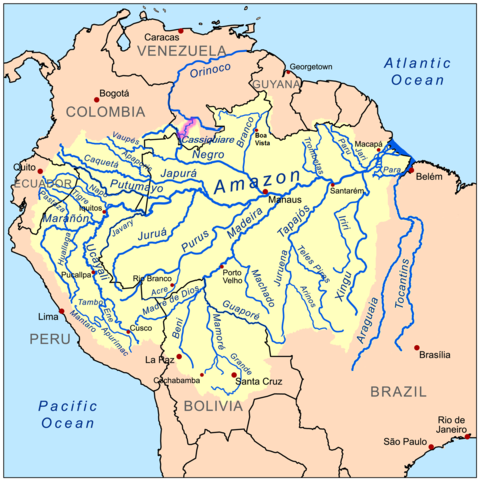
| Descrition | This is a map of the Amazon River drainage basin with the Casiquiare River highlighted. |
| Date | |
| Fonte | Own work using Digital Chart of the World and GTOPO data. |
| Autor | Kmusser |

|
This map image could be re-created using vector graphics as an SVG file. This has several advantages; see Commons:Media for cleanup for more information. If an SVG form of this image is available, please upload it and afterwards replace this template with
{{vector version available|new image name}}.
It is recommended to name the SVG file “Casiquiarerivermap.svg”—then the template Vector version available (or Vva) does not need the new image name parameter. |
I, the copyright holder of this work, hereby publish it under the following license:
Ti file is autorisat sub li autorisation Creative Commons - Atribution-Distribution in Conditiones de Egal Autorisation 3.0 Non-Adaptat.
- Vu es líber:
- distribuer – a copiar, distribuer e transmisser li labor
- remixter – adaptar li ovre
- Sub li conditiones quam seque:
- atribution – Vu deve dar li credite convenent, provider un catenun por li autorisation, e indicar si changes esset fat.
Vu posse far in qualcunc forme rasonabil, ma ne de forma que suggeste que li autorisator indossa vu o tui usu.
- distribuer in conditiones de egal autorisation – Si vu remixter, transformar, o constructer sur li materiale, vu deve distribuer tui contributiones sub li autorisation identic o campatabil quam li original.
Versiones del file
Clacca a un date/témpore por vider ti version.
| Version de | Miniatura | Dimensiones | Usator | Comentarie | |
|---|---|---|---|---|---|
| actual | 05:26, 19 julí 2013 | | 1,500 × 1,500 (974 KB) | Hallel | Removendo rios Tocantins e Araguaia, pois não são mais classificados como parte da Bacia Amazônica |
| 16:39, 9 septembre 2008 |  | 1,000 × 1,000 (538 KB) | Kmusser | {{Information |Description=This is a map of the Amazon River drainage basin with the Casiquiare River highlighted. |Source=Own work using http://www.maproom.psu.edu/dcw/ Digital Chart of the World and [[ht |
Usu del file
Li sequent págine usa ti file:
Usu global del file
Li altri wikis a sequer usa ti-ci file:
- Usu in azb.wikipedia.org
- Usu in br.wikipedia.org
- Usu in ca.wikipedia.org
- Usu in cs.wikipedia.org
- Usu in de.wikipedia.org
- Usu in en.wikipedia.org
- Usu in en.wiktionary.org
- Usu in eo.wikipedia.org
- Usu in es.wikipedia.org
- Usu in eu.wikipedia.org
- Usu in fa.wikipedia.org
- Usu in fi.wikipedia.org
- Usu in fr.wikipedia.org
- Usu in hi.wikipedia.org
- Usu in hr.wikipedia.org
- Usu in it.wikipedia.org
- Usu in ja.wikipedia.org
- Usu in ka.wikipedia.org
- Usu in kbd.wikipedia.org
- Usu in kbp.wikipedia.org
- Usu in ky.wikipedia.org
- Usu in nl.wikipedia.org
- Usu in no.wikipedia.org
- Usu in pl.wikipedia.org
- Usu in pnb.wikipedia.org
- Usu in ro.wikipedia.org
- Usu in ru.wikipedia.org
- Usu in sh.wikipedia.org
- Usu in sl.wikipedia.org
- Usu in sr.wikipedia.org
- Usu in sv.wikipedia.org
- Usu in tr.wiktionary.org
- Usu in uk.wikipedia.org
- Usu in www.wikidata.org
- Usu in zh.wikipedia.org