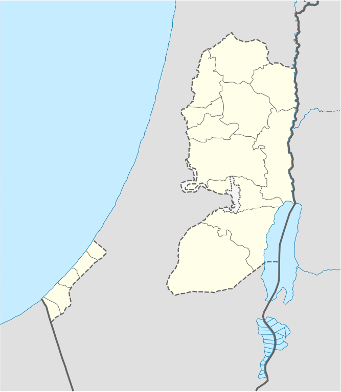
File:West Bank and Gaza Strip location map.svg

Size of this PNG preview of this SVG file: 520 × 599 pixeles. Altri resolutiones: 208 × 240 pixeles | 417 × 480 pixeles | 667 × 768 pixeles | 889 × 1,024 pixeles | 1,778 × 2,048 pixeles | 639 × 736 pixeles.
Original file ((file SVG, nominalmen 639 × 736 pixeles, mesura de file: 98 KB))

|
The boundaries on this map show the de facto situation. This is just one of several different views on the subject (see COM:NPOV). |
Descrition
| Descrition |
Deutsch: Positionskarte der Palästinensische Autonomiegebiete bzw. von Westjordanland und Gazastreifen
Quadratische Plattkarte, N-S-Streckung 115 %. Geographische Begrenzung der Karte:
Equirectangular projection, N/S stretching 115%. Geographic limits of the map:
|
||
| Date | |||
| Fonte |
Own work using:
|
||
| Autor | NordNordWest | ||
| Other versions |
Derivative works of this file: |
||
| SVG genesis | This W3C-invalid map was created with Adobe Illustrator, and with Inkscape.
|

Autorisation
I, the copyright holder of this work, hereby publish it under the following licenses:

|
Permission es concedet por copiar, distribuer e/o modificar ti document sub li conditiones del Autorisation de Documentation Líber del GNU, Version 1.2 o qualcunc version posteriori publicat per li Free Software Foundation; che nequant Section Ínvariant, nequant Textu de Covriment, e nequant Textu de Contra-Covriment. Un copie del autorisation es includet in li section nominat Autorisation de Documentation Líber del GNU. |
Ti file is autorisat sub li autorisation Creative Commons - Atribution-Distribution in Conditiones de Egal Autorisation 3.0 Non-Adaptat.
- Vu es líber:
- distribuer – a copiar, distribuer e transmisser li labor
- remixter – adaptar li ovre
- Sub li conditiones quam seque:
- atribution – Vu deve dar li credite convenent, provider un catenun por li autorisation, e indicar si changes esset fat.
Vu posse far in qualcunc forme rasonabil, ma ne de forma que suggeste que li autorisator indossa vu o tui usu.
- distribuer in conditiones de egal autorisation – Si vu remixter, transformar, o constructer sur li materiale, vu deve distribuer tui contributiones sub li autorisation identic o campatabil quam li original.
Vu posse selecter li autorisation de tui selection.
Versiones del file
Clacca a un date/témpore por vider ti version.
| Version de | Miniatura | Dimensiones | Usator | Comentarie | |
|---|---|---|---|---|---|
| actual | 11:35, 28 april 2009 | | 639 × 736 (98 KB) | NordNordWest | area of West Bank back to correct position |
| 02:02, 28 april 2009 |  | 639 × 736 (109 KB) | Fjmustak | 0.85px solid governorate lines (consistent with Israel, Jordan, Lebanon, etc...) | |
| 18:58, 22 april 2009 |  | 639 × 736 (98 KB) | NordNordWest | corr | |
| 02:02, 17 april 2009 |  | 638 × 734 (119 KB) | Fjmustak | Added governorate boundaries | |
| 18:30, 29 novembre 2008 |  | 638 × 734 (103 KB) | NordNordWest | ||
| 20:05, 19 novembre 2008 |  | 638 × 734 (118 KB) | NordNordWest | {{Information |Description= {{de|Positionskarte der Palästinensischen Autonomiegebiete bzw. von Westjordanland und Gazastreifen}} Quadratische Plattkarte, N-S-Streckung 115 %. Geographische Begrenzung der Karte: |
Usu del file
Li sequent págine usa ti file:
Usu global del file
Li altri wikis a sequer usa ti-ci file:
- Usu in af.wikipedia.org
- Usu in als.wikipedia.org
- Usu in an.wikipedia.org
- Usu in ar.wikipedia.org
- Usu in az.wikipedia.org
- Usu in ba.wikipedia.org
- Usu in be-tarask.wikipedia.org
- Usu in be.wikipedia.org
- Usu in bg.wikipedia.org
- Usu in bn.wikipedia.org
- Usu in ce.wikipedia.org
- Usu in ckb.wikipedia.org
- Usu in cs.wikipedia.org
Vider plu del usu global de ti-ci file.